Saturday, December 17, 2016

'Tis the Week of the Solstice

The Sun stops (not really) . . .
This view of Earth helps depicts the Earth on the Winter Solstice (around December 21 each year). It shows why days are so short and nights so long this time of year. To fully understand the shortness of our days, here's a few things to keep in mind:

1. Earth orbits the Sun once every 365.25 days.

2. The Earth's axis is tilted 23.5 degrees*. If it weren't, there would be no seasons and every place in the world would have 12 hours of daylight and 12 hours of darkness every day of the year. A common misconception about the seasons is that they are caused by Earth being closer or farther from the Sun at different times of the year. THAT IS NOT CORRECT. In fact the Earth is about 3 million miles closer to the Sun in early January than it is in early July! The average distance from the Earth to the Sun is 93 million miles.

3. The Earth spins on its axis once every 24 hours. This axis runs through the Earth from the North Pole to South Pole.

4. Around December 21, Earth reaches the position on its orbital path where the Northern Hemisphere is tilted away from the Sun. Six months from now, Earth will be on the opposite side of the Sun and our hemisphere will be "leaning" toward the Sun.

Good news and bad news . . .
As shown on the image, on December 21, residents of Helena (star) could have observed sunrise at 8:09 AM. (The large yellow circle shows the path of Helena during the 24 hours it takes Earth to spin on its axis.) As Earth continued to spin, Helena moved into darkness (sunset) at 4:43 PM. So, on this, the "shortest day" of the year, Helena experienced only 7.5 hours of daylight followed by 16.5 hours of darkness. In comparison, Anchorage, Alaska (A) would have experienced about 6 hours of daylight (sunrise at 10:14 AM, sunset at 3:41 PM). The good news is that after December 21, the amount time that Montana gets to spend in the Sun increases by minutes per day. This trend will continue until the Summer Solstice in June.

NOTE: The term "solstice" means "Sun stops." This term is used for December 21 because this is the day that the Sun stops getting lower in the sky (also directly related to Earth's tilt and the position of Earth on its journey around the Sun). This day is also the first official day of winter. On the Summer Solstice (first day of summer), the Sun stops getting higher in the sky.

*The tilt of Earth's axis does change slightly over tens of thousands of years, but the change during the course of one year is insignificant. Term: equinox

Thursday, December 15, 2016

A picture is worth a thousand words . . .

It is very important that students understand how water drains off the land to form streams and rivers that eventually (usually) flow to the ocean. Images like this will definitely help. CLICK HERE to see several other images and an impressive animation, created by Imgur user Fejetlenfej,a geographer and GIS analyst.

A map such as the one shown above can be very effective in helping explain the concept of watersheds (and divides). Click on the map to enlarge - and appreciate the detail. It might also serve as the focus of a "bell-ringer". For example, have students write out 3 quality questions about the map - stipulating that each question must begin with the word "why". Then in your discussion of the bell-ringer, ask if they would be able to use the map to mark the location of the Continental Divide (aka the Great Divide).

Friday, December 9, 2016

Great 15-second video of a microburst!

If you know of a better video of a microburst, let me know. This one is great! For more about microbursts CLICK HERE.

8-30-15 - Wet Microburst Chandler Arizona from Monsoon Tracker on Vimeo.

Scroll down for older posts, or use the search box in margin to upper right.

Sunday, December 4, 2016

Refraction Caused by a Temperature Inversion

This photo (courtesy of bigskywalker.com) was taken from the Continental Divide trail, about 30 miles northwest of Helena, MT. The valleys were in the midst of a foggy temperature inversion, and a Fata Morgana (superior mirage) was present over the distant mountains. “Fata Morgana” is so-named because it is the Italian name for the Arthurian sorceress Morgan le Fay, and it was believed that she created these illusions of distant castles or land to lure sailors to their deaths. In reality all mirages are due to refraction (bending, redirecting) of light from distant objects - the strange shapes in the photo are the result of light waves from distant mountains being refracted as they traveled through layers of various temperatures (diagram). Apparently the temperature inversion that blanketed the area was one of the factors that allowed the sorceress to do her handiwork. For more about this hike (including many more photos), go to bigskywalker.com.

Wednesday, May 4, 2016

Shonkin Sag Laccolith - Born of Fire and Ice

Do you think Charlie knew?
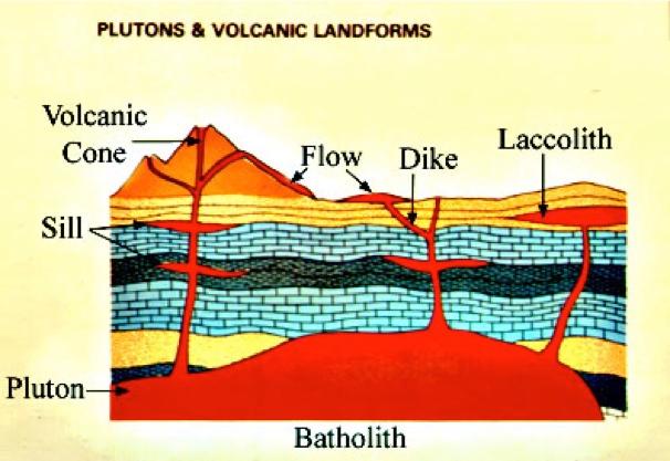
Fifty million years before Charlie Russell painted scenes of central Montana, a volcano dominated the landscape east of Great Falls - The Highwood Mountains are the eroded remains of this ancient volcano. In fact many of the buttes and mountains that form the backdrop in Russell's paintings were formed by ancient volcanic activity. Case in point - In his painting "When the Land Belonged to God", three landforms associated with ancient volcanism appear on the horizon to the right of the bison - Square Butte, Round Butte, and the Highwoods. The chamber that provided the magma for these features is also responsible for the dark cliff shown in the photos on this page. Pressure from magma beneath volcanoes can cause surrounding bedrock to crack, and then magma moves into the cracks or between layers of sedimentary rock, hardening beneath the surface. If a magma-filled fissure cuts across layers of sedimentary rock, the formation is called a dike. If magma forces its way between layers of rock, it is called a sill. If enough moves in to cause layers above to dome up, the formation is referred to as a laccolith (diagram). Square Butte and Round Butte are both laccoliths, and so is the cliff shown above. Stay tuned for more about this famous cut bank later. (geology map of the area).

Does anyone feel a chill?
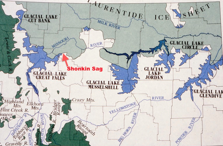
Fast-forward to 2.6 million years ago (mya) . . . The Highwood Volcano had gone extinct, and erosion had taken it's toll on the cone(s) and the sedimentary layers that the dikes and laccoliths were embedded in, exposing some as ridges and buttes. Also, by around 2.6 mya, the planet had cooled enough for another ice age to get started. From 2.6 mya until 12,000 years ago, Earth experienced several glaciations (popularly called "ice ages"). Over tens of thousands of years, great ice sheets grew southward from Canada into the northern Montana (map). Then those glaciers would melt, replaced by warmer "interglacial periods" that would last for thousands of years before next glacial period started. Over the past 1 million years these glacial periods occurred roughly once every 100,000 years. The most recent one ended 12,000 years ago, marking the end of the Pleistocene epoch.

Here comes that dam glacier!
The formation and flooding of Glacial Lake Missoula (multiple times) is one of the most famous events that occurred during the most recent glaciation. However, a lesser-known incident that shaped the cliff shown in the photos on this page was also quite dramatic. Here is one hypothesis** . . . The strange set pf circumstances began when the Laurentide Ice Sheet grew southward from Canada, reaching the north slopes of the Highwood Mountains. As the ice sheet pinched against the Highwoods, it blocked the flow of the ancient Missouri River, causing the formation of Glacial Lake Great Falls (map). At times the lake was about 500 feet deep where the courthouse sits in Great Falls today, and lake water backed up as far south as the Helena Valley.

The big spill.
The lake eventually grew high enough to spill over the dam near the present-day town of Highwood. At some point the ice dam burst, and water rushed along the southern edge of the ice sheet (along the north side of Highwoods) across existing drainages, carving the impressive channel known today as the Shonkin Sag. Eventually the ice grew back, the lake refilled, and the dam burst again - probably numerous times. Today the wide, deep, dry channel with scattered brackish lakes winds its way between the small towns of Highwood and Square Butte (photo and map).

Not so fast!
Gerald Davidson, a retired research scientist who spent years studying the area, agrees that outburst floods are part of the story, but thinks the area's unique landscape was shaped by a more complicated sequence of events that happened over a longer span of time. According to Davidson, "For the past million years the Earth has spent most of the time locked in ice; so there has been sufficient time for a river to gradually cut a channel around the ice - a channel that could have been scoured and enlarged by several violent overflow events."

Above: Photo by Mark Smith - a closer look at the cliffs of the Shonkin Sag Laccolith

That's some cut bank!
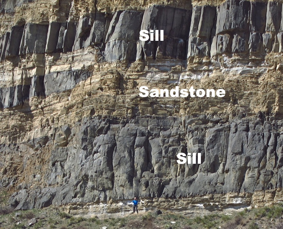
For geologists who visit this remote area to see the Shonkin Sag, the cliff shown in the photos on this page is a "must see". Here, two very different events, separated by tens of millions of years - a period of volcanism and an ice age, teamed up to provide this unique cut bank. This is where ice age torrents of water in the Shonkin Sag cut into the Shonkin Sag Laccolith, exposing the spectacular cross-section represented by the cliff. Such views of plutonic formations are rare - something normally only seen in textbook diagrams. In the photo above, the thick dark part toward the left is eastern edge of the laccolith, and the dark stripes on the right are sills formed as magma from the laccolith squeezed between layers of sandstone (diagram). The photo below, which was taken from the top of Square Butte (4-5 miles away), provides a much different perspective. The laccolith is about 200 feet thick and a mile long. Click here for a close-up of the sills.

Below: Cliffs of the same Shonkin Sag Laccolith - photo taken from top of Square Butte

Term: outburst flood

*Note: The use of the term "ice age" is confusing. For more about this, click here.

Blog and Photos from Hike to Shonkin Sag in April 2016
Lost Lake - Another product of the Shonkin Sag
More Montana Pictures of the Week

Saturday, December 5, 2015

Time-Lapse of Meandering River (28 years)

Click on THIS LINK to watch a river in Bolivia change over a 28-year period. For more about oxbow lakes, CLICK HERE.

Photo courtesy of NASA

Wednesday, December 2, 2015

Excellent New Climate Change Resources

In response to the climate change conference currently taking place in Paris, some great new resources have appeared. Check out this slick interactive graph (www.bloomberg.com), and then watch the very good video segment below, which aired on PBS Newshour this evening (12/2/15). Here's another - featured on the NY Times site: Short Answers to Hard Questions About Climate Change.